Tree Radar
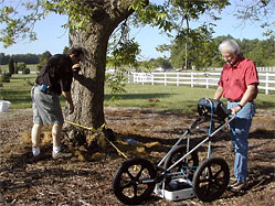
Tree Radar provides inspection services for either trunk internal decay imaging and/or subsurface structural root biomass mapping.
A tree trunk is scanned at multiple elevations – typically 6 ft, 5 ft, 4 ft, 3 ft and 2 ft in under 30 minutes. A complete ground roots scan can be performed in 30 to 60 minutes.
You are provided with a professional graphical report that shows:
- Cross-sectional image at each elevation scanned
- Plot of remaining solid wood thickness at each elevation scanned
- Comments from the arborist regarding interpretation of the images
- Plot of subsurface structural root density showing the 360-degree
shape and extent of the subsurface root structure at varying distances from the trunk
These results can then be used, along with other traditional criteria, to assess the risk for a tree whose health and structural integrity may have been compromised by decay and loss of solid wood.